
Many of us participated in the revitalization “charrettes” on February 17 and 18. Everyone I have spoken to about it said that it was a great success (thanks, Seth, Joyce, and all). Many thoughtful and innovative ideas emerged from that process, but my favorite part is the maps. There are 16 of them. Because it is hard to deal with 16 maps, I have condensed their conten onto just four, which you will find below. There is one map each for possible locations of apartments, cottages, bus parking/transportation office, and storage.
What we did in the charrettes. For those of you who didn’t take part, let me summarize the task we were given. (Those who participated can skip this section.) We were separated into 16 groups of 7 or 8 residents (8 groups in the morning and 8 more in the afternoon), each in a Zoom break-out room. Each group had to place various “features” on an interactive map handled by a facilitator (a member of the architectural team). The features included 30 housing units (at least 10 of which had to be apartments with an indoor attachment to the Center), additional parking (for residents and for buses), a small transportation office, a storage building, an extension to the Center, and various outdoor “amenities” (gazebos, pavilions, sports facilities, etc.). We also had to come up with a “program” (a list of preferred uses) for the Barn.
Not all of these items are necessarily part of the long-term plan for Kendal. For example, the bus parking and transportation office (which must share the same location), and the storage building might be at Crosslands rather than here, and there won’t necessarily be an expansion of the Center (apart from the expansion of the health wing that is already being planned).
In the course of placing the features on the map, we also made observations about other changes we would like to see (and things we definitely did not want changed). These were written down by the facilitator in each group.
On January 18th, a summary session was held on Zoom. Volunteer residents, acting as spokespersons for their particular groups, reviewed the map created by that group and explained the choices they made.
You can watch the video of the summary session here (1 hr. 48 min.). You can look at the 16 maps and the associated bullet-point list of comments made by each of the 16 groups by going here.
How will these maps be used? Joyce Lenhardt, head of the architecture firm we are using, described the next steps at the January 18 session by saying: “We, the design team, will … synthesize all that we’ve heard, and we [will add] our own expertise and our professional experience. We will come back with some recommendations that aren’t necessarily set in stone, but will provide feedback and response for what will be in the final revitalization plan.” There will be further opportunity for discussion at that stage, she said.
The implication is that the maps will be one element in devising a plan, but there will be other factors as well.
Boiling down 16 maps to four. The 36-page document of charrette summary material linked above, containing 16 pages of maps and 16 pages of comments, is a bit overwhelming. But as you look at the maps, certain patterns emerge. Many of the groups chose the same location for a given feature. In this blog post, I will focus on the maps. To me, they were both the most important and the most interesting aspect of the exercise.
What I have done for this blog post is to compile all the maps into just four: a map of cottage locations, a map of apartment locations, a map of locations for the bus parking and transportation office, and a map for the location of the storage building.
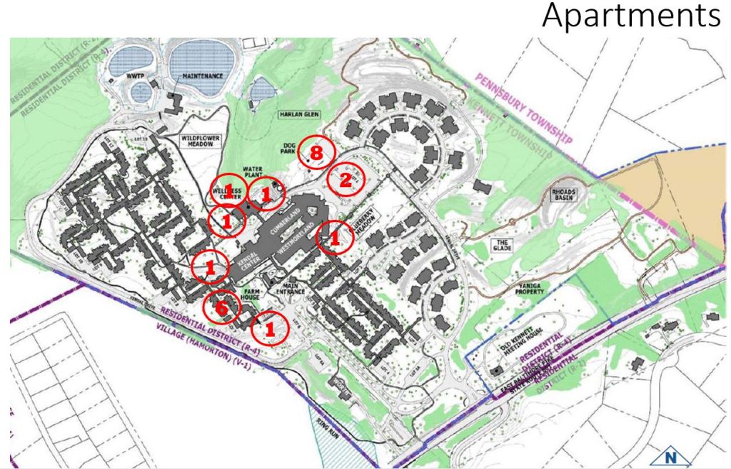
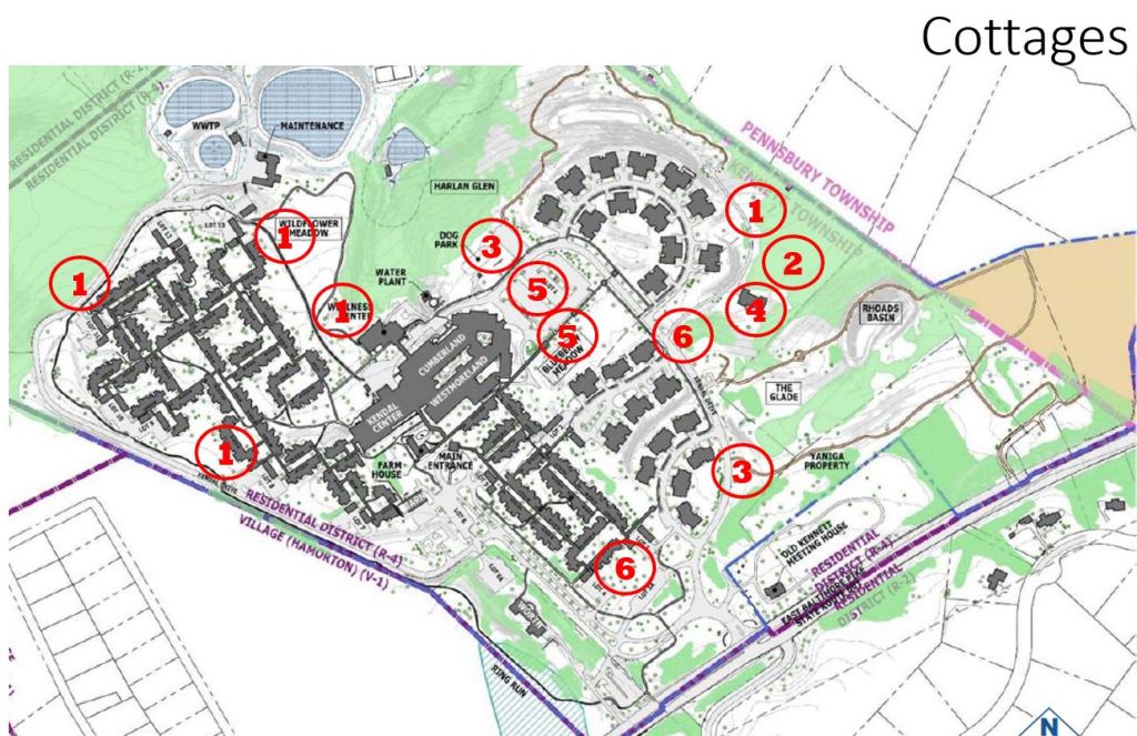
On each of the maps, I have placed circles containing numbers. These indicate how many times that location was selected by a group. For example, a circled “5” at the Blueberry Meadow on the Cottages map means that five groups selected that as a possible location for cottages. (On the Apartments and Cottages maps, the numbers total to more than 16, since each group typically chose more than one location for cottages and apartments.)
Apartment location choices. The map below shows the locations chosen by the charrette groups for apartment buildings connected to the center. As you can see, the most popular location was the Dog Park vicinity (which 8 groups chose). That location would not require any demolition, but the indoor connection to the Center would be quite long. The second most popular was the area near the library door, roughly the area now occupied by cottages with numbers in the 78-91 range. Six groups liked that location. In this case, of course, the existing cottages would have to be torn down.
No other location was selected by more than two groups.
Cottage location choices. The map below shows locations that the charrette groups picked for new cottages. The two most popular were the current parking lot 3A and the corner where Kendal Drive meets the semi-circle of new duplex cottages. Both of those were picked by 6 groups. Next came the edge of the Blueberry Meadow and current Parking Lot 1 (the lot, mostly used by employees, adjacent to Lower Cumberland). These were picked by 5 groups each.
If Parking Lot 1 were to be used, its parking would have to be replaced. The five groups suggested that it could be put underground, with cottages (complete with landscaping) built on top of it. Cottages in this area would serve as a link between the Center and the duplex cottages on the semi-circular drive.
One location, at the start of the Sunrise Trail, near the Old Meetinghouse, was chosen by three groups. No other location was chosen more than twice.
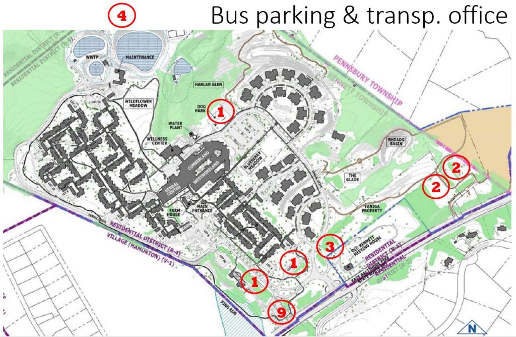
Bus parking choices. The locations chosen for bus parking, and the associated transportation office, were generally as far as possible from residences. Concerns were expressed about idling noise or fumes, but what I hear from Crossland residents near the current bus lot is that the back-up beeping is the real problem.
By far the most popular location for the buses was the far end of the Worth Building lot, right next to Route 1. Nine groups picked that spot. Another four groups chose areas in back of the Meetinghouse cemetery. Yet another four chose the area beyond the tennis courts and gardens (which wasn’t even on the map provided). Three groups chose a spot near the front entrance, just beyond the Old Meeting House.
Several groups suggested that the most efficient location for bus parking would be at Crosslands rather than Kendal, since Crosslands makes heavy use of them getting people to and from meals and other events at their Center, and Kendal does not. It was explained that charrettes on both campuses were asked for their preferences for bus parking, so that the best single solution could be picked. There will not be two bus lots.
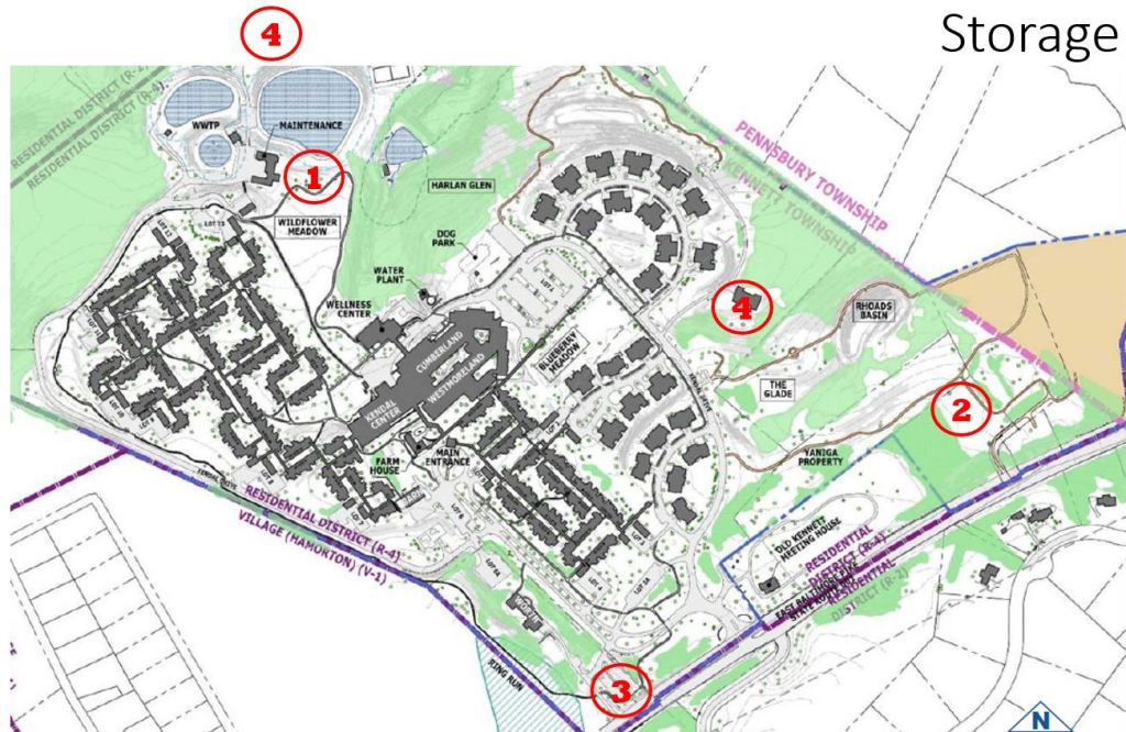
Storage building choices. The storage building could also be on either campus. But if it is at Kendal, there was a preference for having it either at the current location of the “506 House” (on the rise above the semi-circle of new duplex cottages) or beyond the tennis court and gardens (off the map). Four groups chose each of those. Another three groups chose the far end of the Worth Building lot, next to Route 1.
By expressing our preferences in these maps, we residents have alerted the design team to the locations we think would be best for each of these features. I hope we have also given them a sense of places where we do not want new buildings (such as the Wildflower Meadow and wooded areas).
An extension to the Center. The maps included many different ideas for extensions to the Center, if needed. Possible improvements included more small meeting rooms, more office space, a more attractive café with better views, and decks off the café/dining room/library for sunning and outdoor eating. Various groups suggested expanding the Center toward the putting green, toward Lot 1, toward the Farmhouse, or toward the circle drive at the porte cochere. An extension toward the putting green or Lot 1 could also incorporate apartments. A lot of creative options came out of this process, but there was no obvious consensus.
The Barn. Most groups suggested meeting rooms, public gathering spaces, and craft spaces for the Barn. Games and recreation facilities were also popular. Three groups mentioned a bistro or coffee shop, and three mentioned space for a hydroponic garden.
In addition to these, there were many other suggestions: apartments, guest rooms (replacing those in the farmhouse), storage space, used furniture (replacing the Shed), a new home for the library, music rooms, and office space for sales and marketing.
Moving facilities, such as the game room, from the Center to the Barn would open up more potential meeting-room space at the Center.
The bulleted lists. In addition to the maps, the charrette facilitators provided bulleted lists of comments made by each of the groups. There are hundreds of these comments, and I can’t begin to summarize them here. You will want to read them for yourself at this link. There are many excellent ideas here, and I hope they are not lost just because they are not part of our architectural plans for revitalization.
Unanswered questions. Although most people considered the charrettes a great success, and they did provide good information about the preferences that residents have for the location of new features, there were important revitalization questions that the charrettes didn’t address. That will be the topic of a future blog post.
