
This is a guest post by Merritt Cleaver. It consists of the text of a talk he gave (and the map he presented) in the Kendal lounge on January 11, 2023, plus some additional material arising from subsequent discussions.

This map came about because of the wonderful digital archives created by Charlie and Sara Hill. I’ve tried to provide them with a few useful documents. When I looked into our property purchases, I was surprised to find more than 30 of them, and to find them poorly described in our files and in county tax records. So I thought a visual aid could be useful to staff and interesting to residents – especially in light of our 50th anniversary. There are two framed copies – one in the Webb-Savery Room at Crosslands, and the other in our alcove. When the alcove copy is taken down at the end of February, I hope it will reside in our conference room.
A look at the map. The borders of each parcel of land are shown, along with the year of acquisition, the previous one or two owners, the street number, and the acreage. The yellow line outlines the present KCC property ownership. The dark black lines are thoroughfares – Route 1 (or E. Baltimore Pike) along the bottom, Route 926 (or E. Street Road) along the top, and Parkersville Road along the right. The red lines are private roads and developments. You can see the maintenance road over the hill and through the woods to Crosslands. The blue color indicates water – the three sewage water treatment ponds (we treat the waste water from Kendal, Crosslands and Cartmel), Spear Pond, Scott Pond, and Bennett’s Run.
Just before it reaches Parkersville Road, Bennett’s Run feeds a mill pond. For about 200 years it powered a saw mill, a grist mill, a butter and cheese creamery, and a cider mill. The first to develop that mill was Samuel Heald, an ancestor of Dick Heald (late husband of our resident CJ Heald) and of Bill Heald in Crosslands. Resident Jim Kauer used to live on this home lot. The green line marks the township line between Kennett and Pennsbury. The east-west portion runs along the crest of the ridge between our communities. The township is important for zoning purposes as well as for apportioning real estate taxes. Even though we were established as a 501(c)3 charity, we offered (and now are committed) to pay real estate taxes.
The line that resembles a railroad track is not a railroad, but the border between Kendal and Crosslands. It travels right behind our gardening and maintenance sheds and water treatment pond #3. During the 1970s we were separate corporations with shared directors. These days the distinction is important because Kendal property is mortgaged under one of our bonds and Crosslands property is mortgaged under another.
A bit of Webb and Harlan history. This “railroad track” was also the northern boundary of the original 200 acres settled by the Harlan family. Kendalites, especially the Quakers among us, might appreciate a bit of English history I discovered from my family’s genealogy. In the 1690s, Elizabeth Webb, a young married Englishwoman with several children, had become respected as a minister among Friends. She decided that she was going to follow in George Fox’s footsteps by travelling to America (as he had done in the 1670s) to provide inspiration and encouragement to Quakers from North Carolina to New Hampshire. Soon after that year and a half mission, she and her family migrated to Pennsylvania, eventually helping to found the nearby Birmingham meeting.
Our connection to this amazing woman is that her eldest son William first settled the large tract of land which includes present-day Crosslands and Cartmel. Succeeding Webb generations built Old Stone at Cartmel, and Ellerslie at Crosslands. Moreover, her younger son, Daniel, purchased the Harlan property, built the west wing of our farmhouse, and this too became a Webb farm for the next hundred years. Both men married Harlan wives. After the Webbs, this land was farmed by Hueys for 60 years and by Hoopes’ for another 60 years. Then, in 1949, it was subdivided.
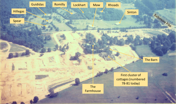
The homes on Meetinghouse Lane. Back to our map. The dashed red line on the lower part of the Kendal property indicates the former Meetinghouse Lane and nine driveways to homes which were built after the 1949 subdivision. At that time, Lawton Burrows, a DuPont executive, purchased the farmhouse and 80 acres. Using a grant from the Philadelphia Yearly Meeting, Kendal purchased the Burrows property in 1971.
Two years later the Spear property, (which had been expanded in 1957 by a 2 acre purchase from Burrows to include the Harlan ruin) became Kendal property so that we began with 85 acres, and the Spears became founding members. Shortly after our doors opened, we purchased a parcel east of the cemetery, probably to allow for eventual expansion of the cemetery.
After the 1973 Spear purchase, it was 15 years before the next Kendal purchase of the Hillegas property when they, too, became residents. The remaining parcels subdivided in 1949 eventually became available to Kendal between 1999 and 2012. At Crosslands, the next major purchases were the 75 acre Scott property in 1994 and the 42 acre Kirkpatrick property in 1996. The deed to our spring house property, from Stillman in 1999, gives us a 40’ right of way along a neighbor’s driveway to Willow Glen Road.
The Rhoads family (who now live at Crosslands) were the last to leave Meetinghouse Lane, enabling Kendal to construct its new cottages. The only house still standing is #506 at the top of the hill behind the new cottages. The small Spear home (1,000 sq. ft.) stood at the east end of our dog park. Part of their driveway still exists by the tiny 6’x6’ pre-school storage building, which was built in 2010 or 2011 to preview the siding for the new cottages.
Name changes. The legal name of this community has changed several times:
1971-1973 Friends Hall
1973-1980 Kendal at Longwood
1975-1980 The Crosslands Corporation
1980-1989 Kendal-Crosslands
1989-1995 The Kendal Corporation
1995-now Kendal – Crosslands Communities
Today, KCC owns 504 acres, (Crosslands 263, Kendal at Longwood 144, Cartmel 62, Coniston 36)
